Monday 7 Mar 2022
Laser and drone technology recreates Victorian viaduct like never before
- Region & Route:
- North West & Central
- | North West & Central: North West
Laser scanners and drones have been used to map every inch of the iconic Whalley railway viaduct in Lancashire to secure its future for passengers and freight.
The 21st century technology is being used by Network Rail to plan essential maintenance over the next six to eighteen months which will secure the 19th century structure for the future.
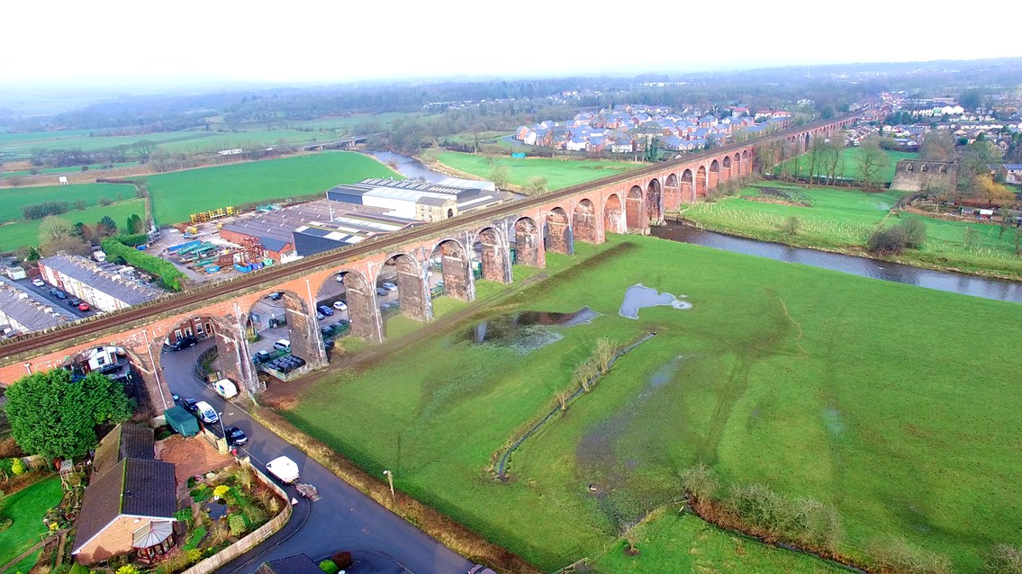
A total of 300 scans were taken of the 48-arch viaduct which carries the Blackburn to Clitheroe railway line 550 metres across the Ribble Valley.
These scans of the 176-year-old structure have now been turned into a 3D computer model, creating a digital blueprint of the viaduct’s current condition.
This allows teams to closely monitor any changes in the structure and identify problems in the ornate Victorian brickwork.
It is also safer for the workforce – previously only manual checks using abseilers or scaffolding towers would find problems in the structure.
Phil James, Network Rail’s North West route director, said: “We’re always looking to innovate on the railway and seeing drones and lasers being used to care for such an historic structure is really impressive.
“Using this 21st century technology gives Whalley viaduct’s engineers a forensic way to plan its essential maintenance for the next 18 months. Great care and attention is going in to make sure our work is right from a heritage perspective. This digital model plays a major role in that as we secure the Grade II listed-structure’s future for passengers, local people and tourists.”
Network Rail has today (7 March) released the impressive footage of the Victorian viaduct as realised by the 21st century technology.
A LiDAR survey* was carried out by contractor Commendium.
Drone flights also took place as part of the survey taking high-definition photographs of the Grade II listed structure.
The data gathered was then used to build up the 3D computer model.
Richard Walters, chief executive officer for Commendium, said: "At first glance, scanning the Whalley viaduct looks easy. However, the proximity of other interests such as a factory, roads, public footpaths and domestic property has made this a more challenging project. The issue has been finding places to scan from so that we could capture all the necessary walls and features of the viaduct. Therefore local stakeholder co-operation has been essential and, frankly, without their enthusiastic help, the job would have been very much harder."
Future maintenance work on Whalley viaduct will see
- brickwork repairs
- removal of vegetation and repairing the damage caused by plants and weeds
- viaduct strengthening work
- work to stop the viaduct's bases – or piers – suffering from river erosion
Nigel Evans, deputy speaker of the House of Commons and Ribble Valley MP, said: “It is fantastic to see this cutting-edge technology being used to preserve such an important and beautiful piece of local history. I know many people travel long distances to see the iconic Whalley railway viaduct and it is so important that it is preserved for future generations. It is through projects like this one that its future can be ensured and I am pleased to see that Network Rail will be undertaking the necessary work to achieve this.”
Trains will continue to run as normal over the viaduct during this essential work.
For more information on how Network Rail maintains viaducts and bridges visit: https://www.networkrail.co.uk/running-the-railway/looking-after-the-railway/bridges-tunnels-and-viaducts/
Notes to Editors
How the 3D computer model of Whalley viaduct was created
*This was done using LiDAR technology.
Over 300 separate scans were taken from locations underneath and on top of the viaduct.
In a LiDAR system, light is emitted from a rapidly firing laser like a strobe light.
This light travels to the ground and reflects off of things like buildings and tree branches. The reflected light energy then returns to the LiDAR sensor where it is recorded.
This data is then used to build up the 3D computer model.
Whalley viaduct key statistics
- 70 ft. high
- 548 metres long
- Has 48 arches
- Was built between 1846 – 1850
Whalley viaduct opened in 1850 – 26 years earlier than the more famous Ribblehead viaduct 25 miles to the north. Whalley is arguably more impressive – built from red and blue brick - 146 metres longer and with double the number of arches than Ribblehead.
Looking after Whalley viaduct
At 548m long, Whalley viaduct’s 48 arches take the railway over the River Calder in the Ribble Valley.
Network Rail is proud to look after such a historic piece of Britain’s railway. Ensuring its Victorian structures remain in safe working order and last for generations to come is a great responsibility.
To do this, engineers undertake visual exams of the viaduct annually and detailed inspections every six years. Network Rail also typically carries out a major renewal every 10 years and any minor works as and when necessary.
About Network Rail
We own, operate and develop Britain's railway infrastructure; that's 20,000 miles of track, 30,000 bridges, tunnels and viaducts and the thousands of signals, level crossings and stations. We run 20 of the UK's largest stations while all the others, over 2,500, are run by the country's train operating companies.
Usually, there are almost five million journeys made in the UK and over 600 freight trains run on the network. People depend on Britain's railway for their daily commute, to visit friends and loved ones and to get them home safe every day. Our role is to deliver a safe and reliable railway, so we carefully manage and deliver thousands of projects every year that form part of the multi-billion pound Railway Upgrade Plan, to grow and expand the nation's railway network to respond to the tremendous growth and demand the railway has experienced - a doubling of passenger journeys over the past 20 years.
Follow us on Twitter: @networkrail
Visit our online newsroom: www.networkrailmediacentre.co.uk